Module 5 - Add Coordinates and Geoprocessing
This week was primarily an introduction to data import and formatting in ArcGIS. Our first task was to import a table of Eagle nest locations in Santa Rosa County, Florida. I manually entered the lattitude and longitude coordinates in a table in excel, then imported the table into ArcGIS. However, the coordinates were in degrees, minutes, and seconds, which doesn't typically work well in GIS. To remedy this, I used Excel to convert the coordinates into "Decimal Degrees" (pictured below). This activity allowed me to learn and practice extracting characters from within Excel cells and using them to complete a conversion equation.
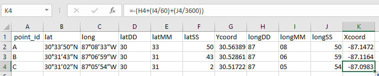 |
| Excel Coordinate Conversion Table |
The practice from the first activity helped me streamline the table formating step in the second activity. I took school name and location data from the Brevard School District webpage and formatted it into an excel table that would work with GIS. I then imported the data and used the Geocoding tool to format multiple cells into an address that GIS could display on the map. However, 14 locations had to be manually entered because GIS couldn't match the data to an address. After I finished that, I shared the final map into a web map (link below). This activity was long due to the manual entry of school location, especially since it took me some time to figure out the best way to do so. I ended up using Google maps to find the address, copied the coordinates, and used the "Locate" tool in GIS to find the address location. I only used locate to get close, though, and found the correct building using the basemap and relative location based on the Google Map location. I am glad that I got to practice Geocoding, though, as it seems like a tool I'll often need in the future when using GIS.
Brevard School District Locations

Comments
Post a Comment